
Trift glacier monitoring
Challenge
In the past decades, the Trift Glacier in the Bernese Oberland between the Gadmen and Hasli valleys has seen a significant retreat, and a large proglacial lake has formed at an altitude of 1,650 m a.s.l. since the year 2000. Retreating further, the glacier now terminates on a steep rock slope at about 2,100 m a.s.l. The remainder of the glacier tongue now forms a large piece of dead ice just below the current terminus. Due to the retreat of the glacier, a large rope bridge had to be constructed to ensure the accessibility of the nearby Trift cabin.
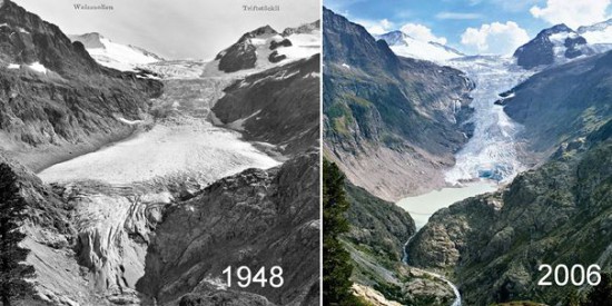
The Trift Glacier 1948 and 2006. Images from ‚Die Alpen‘ issue 07/2014.
Glaciers terminating in steep terrain are potentially hazardous: large ice volumes can detach from the glacier and produce an ice avalanche. In a similar situation, a large ice avalanche from the Allalin Glacier killed 88 men working on the construction site of the Mattmark Dam in 1965. Ice masses from the Trift Glacier reaching the lake would cause severe tidal waves that would pose a considerable threat to people on and in the vicinity of the lake. In order to detect such a tidal wave and any speeding up of the glacier tongue and to warn the surrounding area of flood waves, GEOPREVENT has installed several alarm- and warning systems.
The glacier movement is well visible in this timelapse movie: Two years of Trift Glacier movement as seen from the Trift cabin (camera images © VAW/ETH Zürich)
Solution
The overall system has a sophisticated design and includes different sensors.
A pressure probe within the lake detects flood waves. In such a case, beacons and flashing lights sound the alarm at the Trif cable car station below the lake, warning personnel and hikers about the danger. During the summer season of 2014, exploratory boreholes are being drilled into the bed of the Trift Lake. These works are conducted from pontoons on the lake, and the warning coming from the pressure probe cannot provide the advance warning needed. For this reason, the existing warning system has been complemented with new elements:
To this day, we have always used our interferometric radar to detect rock deformations at a millimetre scale. In this case, we use the radar on ice instead of rock, and the velocities are in the range of meters per day. Additionally, the independence of weather conditions provided by the radar technology provides a huge advantage over other methods, especially in this alpine environment. From a distance of 1.5km, we can measure the velocities at the glacier terminus – alerting the responsible glaciologists if certain thresholds are surpassed.
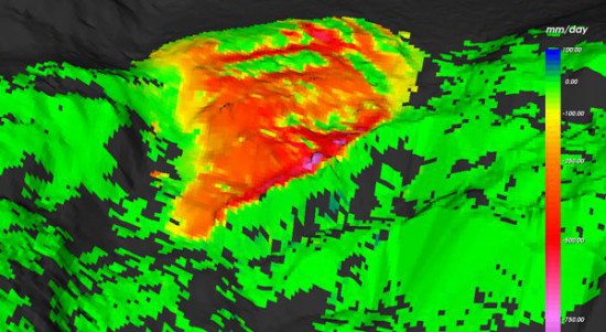
The radar permanently procures deformation rates at a high spatial resolution. At the moment, daily velocities lie at around 0.5 meter per day.
Three webcams shoot images of the glacier at regular intervals, allowing us to determine the glacier movement based on feature tracking within the images (see Figure 6). All webcam images can be accessed on our data portal, providing valuable information on the weather for the planning of the drilling works.
Observations by the staff of the nearby Trift cabin and the construction workers provide another warning element of the surveillance system. Any observation can be sent to our servers by SMS, and appear as messages on our online data portal. These messages have to be marked as read by all involved, guaranteeing that important information cannot be overseen.
More information
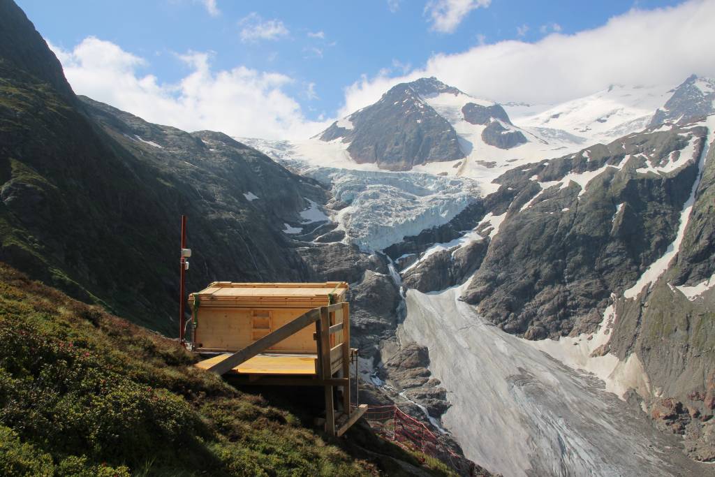
The customized Radar-Chalet with view onto the Trift Galcier.
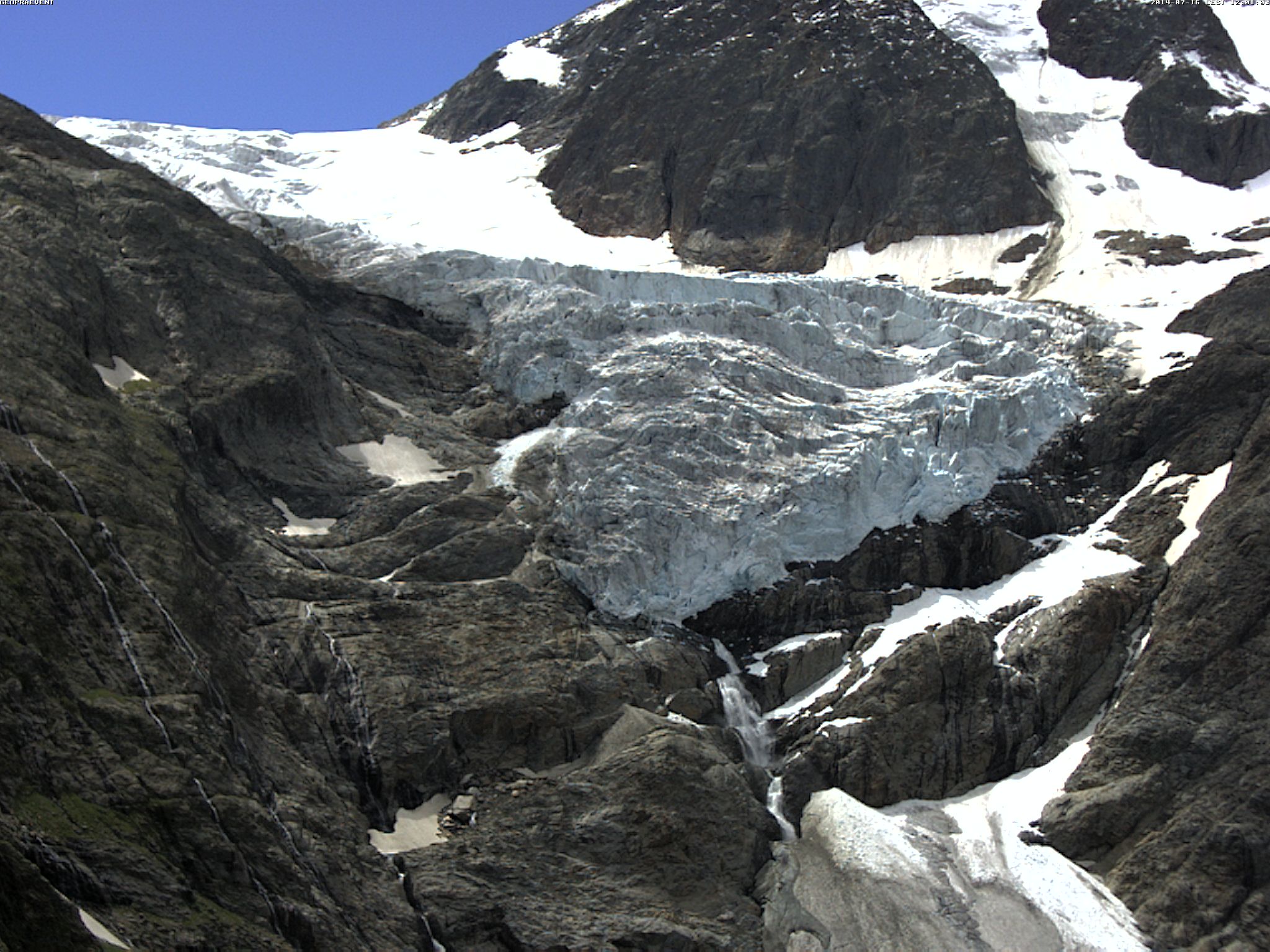
Webcam view from the radar position. This camera supplies a live-image function, allowing us to double check results from the radar analysis at any time.
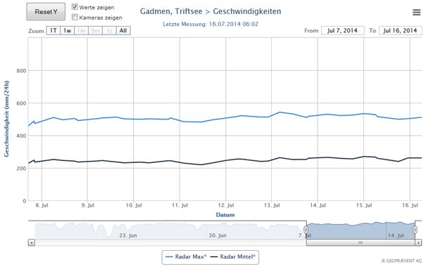
In our data portal, velocity plots covering the whole measurement period aid the assessment of the current situation.
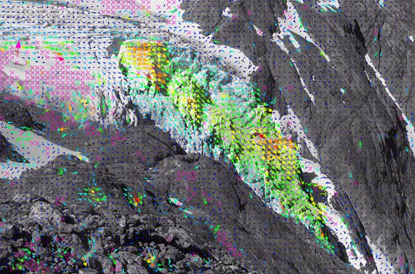
Displacement monitoring based on image analysis.
Customer
![]()